Bend - (9 Miles; O&B) - Perry Riffle to Massacre Flat
Bend Ferry RoadBend, California 96080
Tehama County
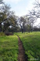
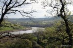
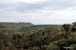
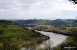
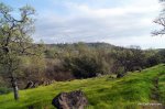
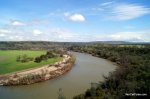
The Yana Trail is long trail that runs through the Sacramento River Bend Area. One of the sections that you can hike is from Perry Riffle to Massacre Flat. This 9-Mile Out & Back trail offers incredible views of the Sacramento River and surrounding areas.
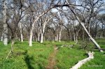
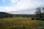
For the most part, the trail runs along the Sacramento River with sections that move out into beautiful meadows, through trees and across a creek. In the Spring and early Summer, the wildflowers are out in full force and the area is just stunning.
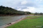
Massacre Flat has a campground, bathroom and a small beach area where you can dip your toes in the water. It's a great place to picnic and re-fuel before heading back.
The trail has slight elevation changes and is fairly free of volcanic rock. We suggest hiking boots although good tennis shoes will get you out and back comfortably. This is a very peaceful hike that offers a good amount of solitude.
Here is a MAP of the trail. It's from Point 13 (Perry Riffle) to Point 10 (Massacre Flat).
Distance: 9 Miles; Out & Back.
Degree of Difficulty: Easy/Moderate
Dogs: Yes, on leash only.
Camping: You can camp at Massacre Flat which is primitive although there are bathrooms.
More info:
You can also take Perry Riffle (13) to Jellys Ferry (9) for a 8.5 mile, one-way hike although you'll need to leave a car at Jellys Ferry. Another great out & back trail in the area is from Jellys Ferry (9) to Massacre Flat (10).
How to get there:
From I-5, a few miles north of Red Bluff, take Jellys Ferry Road and then take a right on Bend Ferry Road (you'll see a sign). Take Bend Ferry Road which will lead you into the park. Follow Bend Ferry Road to the end and you'll see the trailhead sign.