 Coffee Creek - (7 Miles; O&B) - Tangle Blue Lake Trail
Road 39N20Coffee Creek (North of), California 96091
Trinity County
Phone: 530-623-2121
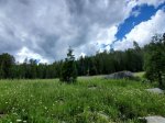
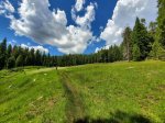
This hike is gorgeous and is only outdone by the lake itself. The trail is on what used to be old jeep road that requires you to cross a few streams on your way to the lake. We had no problem with any of the crossings the second week of July.
The trail has plenty of sun but also plenty of shade to give a good mix of both. For most of the trail, you also get to enjoy the sounds of Tangle Blue Creek.
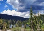
The hike is uphill more or less the whole way up to the lake but is fairly gradual and should be manageable for most. The hardest part of the hike is just before you reach the lake, where the incline of the trail chances noticably. It's not too dramatic but you'll know you're almost to the lake when you hit this point.
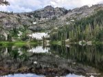
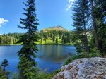
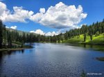
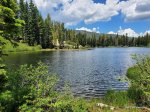
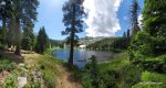
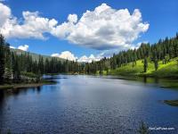
Once you get to the lake, the views are stunning. The lake is simply beautiful and the surroung peaks act as an intimidating and towering backdrop.
If you're facing the lake, head right and go throug the campground and you'll spot a trail that runs along the right side of the lake. This trail will leads you to the rocks that you will directly across the lake when you first arrive. It's a short hike and one definitely worth taking.
The hike back is very mellow and easy.
Here is a short video of our recent hike to Tangle Blue Lake.
Distance: 7 Miles. We've seen a few different distances reported for this trail, including the sign near the trailhead which states 2.5 miles each way. We're pretty confident it's seven miles.
Degree of Difficulty: A pretty easy trail if you hike often and/or are in good shape. A moderate but manageable hike for those who are occasional hikers.
Dogs: Yes. On Leash.
Camping: There is a campground along the lake. It's dispersed camping so first come, first served. It's free to camp here but pack out all your trash.
How to get there:
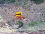
From Coffee Creek, heading north on Highway 3, take the first left after you cross Scott Mountain Creek; appromximatley 13 miles. The road is 39N20 and is not really marked (take a look at our photos). The road is on a hairpin turn and will be on your left so be careful making the turn. Once you're on Road 39N20, follow it for about 2 miles, until you reach the gate. The trail is beyond the gate.
*4-Wheel Drive is highly suggested.
More info:
The lake area was very clean when we visited. Apparently the peple who visit here care about taking care of the areas they love. When you visit, please be one of these people.
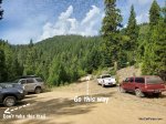
There are two trailheads at the parking lot; one of them is false and leads to an impassable area. Take a look at the photos for a visual idea of which path to take.
Take lots of water and some food. The lake is a great place for a picnic.
*Click on the photos below to enlarge them